KICD Weather Room 3/11/26 — Wednesday afternoon may bring a little lighter rain or snow—snow is more likely north of I‑90 and rain more likely south—though any snow will melt quickly as highs reach the 40s. Winds will gust 25 to 30 mph Wednesday afternoon before calming in the evening, with lows in the mid‑20s. On Thursday, winds strengthen again with gusts of 30 to 40 mph and very dry air, leading to Elevated Fire Danger and a Fire Weather Watch from 11 AM to 9 PM. Late-day light rain may try to develop in northern areas but may not reach the ground. Thursday night into Friday morning, a passing Clipper system will bring even stronger winds, with gusts of 35 to 45 mph and isolated gusts over 50 mph possible. A High Wind Watch is in effect from 10 PM Thursday through 7 AM Friday.
FIRE WEATHER WATCH IN EFFECT FROM THURSDAY AFTERNOON THROUGH THURSDAY EVENING FOR WIND AND LOW RELATIVE HUMIDITY FOR AREAS SOUTH OF A LINE FROM HURON TO SIOUX FALLS, TO STORM LAKE…
The National Weather Service in Sioux Falls has issued a Fire Weather Watch for wind and low relative humidity, which is in effect from Thursday afternoon through Thursday evening.
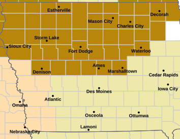
* AFFECTED AREA…In Iowa, Lyon, Osceola, Dickinson, Sioux, O’Brien, Clay, Plymouth, Cherokee, Buena Vista, Woodbury and Ida. In Nebraska, Dixon and Dakota. In South Dakota, Beadle, Gregory, Jerauld, Sanborn, Miner, Lake, Brule, Aurora, Davison, Hanson, McCook, Minnehaha, Charles Mix, Douglas, Hutchinson, Turner, Lincoln, Bon Homme, Yankton, Clay and Union.
* WINDS…Southwest 20 to 30 mph with gusts up to 45 mph.
* RELATIVE HUMIDITY…As low as 26 percent.
* IMPACTS…Any fire that develops will catch and spread quickly. Outdoor burning is not recommended.
PRECAUTIONARY/PREPAREDNESS ACTIONS…
A Fire Weather Watch means that critical fire weather conditions are forecast to occur. Listen for later forecasts and possible Red Flag Warnings.
-0-
…HIGH WIND WATCH IN EFFECT FROM THURSDAY EVENING THROUGH FRIDAY MORNING…
* WHAT…Northwest winds 20 to 30 mph with gusts up to 45 mph possible.
* WHERE…Portions of northwest and west central Iowa, southwest Minnesota, northeast Nebraska, and central, east central, south central, and southeast South Dakota.
* WHEN…From Thursday evening through Friday morning.
* IMPACTS…Damaging winds could blow down trees and power lines. Widespread power outages are possible. Travel could be difficult,
especially for high profile vehicles.
PRECAUTIONARY/PREPAREDNESS ACTIONS…
Monitor the latest forecasts and warnings for updates.